Saturday August 1st, 2026
Eugene, Oregon
Distance: 100k · Ultra
Offical Race Web Site
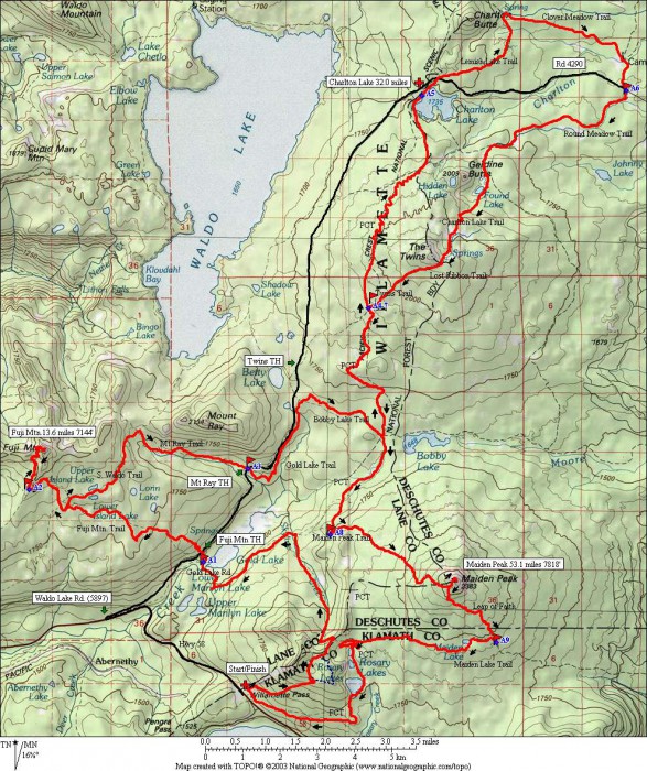
Waldo 100k Trail Run is mostly single-track trail with more than 11,000′ of elevation gain and an equal amount of loss. There are three major climbs of more than 2,000′ each and two minor climbs of more than 1,000′ each. The highest point is 7,818′ at the top of Maiden Peak and the lowest point is at Gold Lake, about 4,900′.
The name of the race was decided on when it was clear that runners could only ever “see” Waldo Lake from the high peaks and never arrive there. Race director Craig’s wife, Laurie Thornley, warned him that someone might come after him regarding the use of the children’s storybook name, but he decided to chance it. Wanting to add some flavor to the normal prize structure, Craig and co-director Curt added a premium for the racers, The “Find Waldo” award would go to the first runner to reach the top of Fuji Mountain (mile 16), but to win the prize the runner had to complete the race.
And thus, Where’s Waldo 100k was born. It was included in the Oregon Trail Series, and with the fair warning, “It is not a beginner-level ultra and participation in the race should not be taken lightly,” the first race was on the calendar for September 28, 2002. A two-person relay was included to get the numbers up.

| Division | Time | Name | Age | Home |
| Male | 9:59:31 | Mario Mendoza Jr | 39 | |
| 2nd Male | 10:07:11 | Robert Ressl | 38 | |
| 3rd Male | 10:10:56 | Eduardo Morales | 30 | |
| 4th Male | 10:11:41 | Jace Ives | 41 | |
| Female | 12:28:11 | Missy Lotz | 43 | |
| 2nd Female | 12:38:30 | Nu Ma | 43 | |
| 3rd Female | 12:57:56 | Heidi Rounds | 44 | |
| 4th Female | 13:32:11 | Laura Westmeyer | 39 |
| Division | Time | Name | Age | Home |

The race begins and ends at Willamette Pass Ski Area, 70 miles southeast of Eugene, Oregon on Highway 58 at an elevation of 5120′. The course is mostly single-track trail with more than 11,000′ of elevation gain and equal amount of loss. There are 3 major climbs of more than 2000′ each and 2 minor climbs of more than 1000′ each. High point is 7818′ at the top of Maiden Peak. Low point is at Gold Lake, about 4900′.
Second half of the course is remote. From the Rd. 4290 (A6) aid station at 37 miles to the finish the course does not cross a road. Dropping out in that section will not make your life much easier. The last 3 aid stations have 1.5, 3.0, and 2.5 mile hikes out on trail, respectively.
The course is not easy.
We attribute this to the amount of single track, the length of the climbs, the altitude, and the length of the course.


